


vers la croix de malte

bernir
User
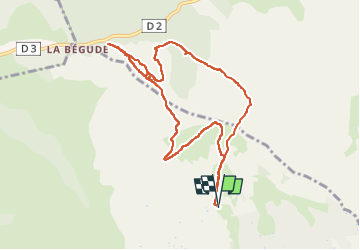

Length
9.9 km

Max alt
430 m

Uphill gradient
331 m
Km-Effort
14.3 km

Min alt
198 m

Downhill gradient
330 m
Boucle
Yes
Creation date :
2025-01-23 09:44:00.507
Updated on :
2025-01-23 17:59:18.897
3h14
Difficulty : Difficult

FREE GPS app for hiking
 SityTrail
IGN / Geographical institutes
SityTrail Plus
The world is yours!
About
Trail Walking of 9.9 km to be discovered at Provence-Alpes-Côte d'Azur, Var, La Cadière-d'Azur. This trail is proposed by bernir.
Positioning
Country:
France
Region :
Provence-Alpes-Côte d'Azur
Department/Province :
Var
Municipality :
La Cadière-d'Azur
Location:
Unknown
Start:(Dec)
Start:(UTM)
721619 ; 4788993 (31T) N.
Comments